EN
EN  PT
PT ES
ES FR
FR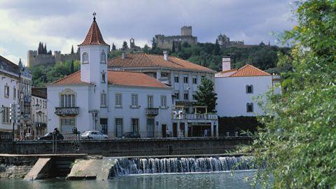
Centro Histórico
The plan of the medieval city is organized in a cross with the 4 arms pointing the 4 cardinal points marked by the 4 convents of the city.


Centro Histórico
Tomar
Description
The center, where the City Hall and the Mother Church are located, is Praca republicaa Praça da República, from which radiate the main public and religious buildings: to the south, the Synagogue, the old Hospital da Misericórdia, the Convento de S. Francisco and the old Rossio da Vila; to the north, the seat of the Municipal Assembly, the chapels of S. Gregório and Senhora da Piedade and the old Convento da Anunciada; to the west, the Castelo hill, the Ermida da Senhora da Conceição and the Convento de Cristo; to the east, the Bridge, the old Moagens and Moinhos da Vila, the Convent of Sta. Iria, the exit to the Church of Sta. Maria do Olival and the school area of the city, with the Polytechnic Institute finishing.
Pursuing this symbolic geometry, it is interesting to note that, with its center in the Manueline church, Praça da República, the circumference that connects the Charola do Convento (Templar oratory) to the Convents of the Announced, of Sta. Iria and S. Francisco is generated.
Here, then, is the circle, like a sacred space, within which Tomar was developed.
Source: http://www.cm-tomar.pt/