EN
EN  PT
PT ES
ES FR
FR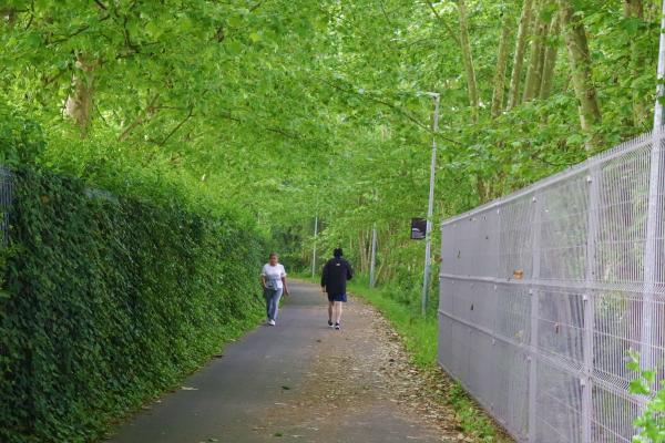
Ecocaminho da Maia
Characterization of the Route: Ecocaminho corresponds to a section of the old Guimarães railway line integrated in a more comprehensive route, this one of approximately 3.3 km, from Quinta dos Cónegos, in the parish of Cidade da Maia, to the old Apeadeiro de Mandim, in extinct parish of Barca, current parish of Castêlo da Maia.
Lugar do Souto.
Maia
Description
Surroundings: Along this route, different landscapes are offered, where wooded areas prevail, confrontations with vegetable gardens, the old Maia train station and agricultural areas.
Floor and signage: This path corresponds to a 3 meter wide paved asphalt road, with public lighting and urban furniture.
The information made available to Ecocaminho users appears in the form of horizontal signage - in made footage, and also in vertical signage - on information panels that are distributed along this route.
Slope: The Bike Path extends in a section corresponding to the old railway channel, in terrain whose inclination varies between 0 and 3%.
Degree of Difficulty: Low difficulty.
Start / End: Via Periférica, place of Souto.
GPS: 41.227811, -8.632450
End / Start: Mandarin.
GPS: 41.251663; -8.627807
Extension: 3,300 meters.
Source: http://www.visitmaia.pt/


Comments
There are no comments!
Partners same locality