EN
EN  PT
PT ES
ES FR
FR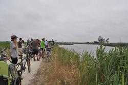
Percurso de Fermelã
The Fermelã route has as an ex-libris the “Bocage”, a habitat that is characterized by the compartmentalization of agricultural fields in patches delimited by living hedges and man-made water veins, allowing excess water to flow during certain periods of the year and at the same time accumulating water in the dry season.
Fermelã
Estarreja
Description
Cows of the marine breed, a native species of the region, graze in the small fields, which by their strength were used in farming and to pull the nets of fishermen of the Xávega art. Along the 10 km of extension it is possible to appreciate a unique landscape, where man tries to control the salt water of the Ria de Aveiro in order to maintain the rural agriculture typical of this region. The route starts at Carregal- Fermelã and ends at Ribeiro de Canelas, thus allowing a continuation to the north of the network of pedestrian and clickable routes.
* Distance to cover: About 10.1 Km
* Duration of the route: Approximately three hours.
* Scope of the route: Environmental, landscape, cultural and sport.
* Degree of difficulty: Easy (no unevenness)
* Recommended season: All year
* GPS coordinates: [Park / Rua Carregal Fermelã _initial [40 ° 42'21 "N 8 ° 33'44" W]; Ribeiro de Canelas_fim [40 ° 42'42 "N | 8 ° 33'49" W]
Source: https://www.cm-estarreja.pt/